Lots 41 and 42 Historical Report, Block 14 Lot 41-42Originally entitled: "Lots 41-42 Block 14"
Colonial Williamsburg Foundation Library Research Report Series - 1306
Colonial Williamsburg Foundation Library
Williamsburg, Virginia
1990
Copy for Architecture
LOTS 41 & 42
Block 14
LOTS 41 & 42
Block 14
IN SUMMARY:
The first known occupant of the property appears to have been John Lockley, merchant. Strong circumstantial evidence seems to indicate that Lockley was living on the property from 1774 to 1785 when he sold to Wyatt Coleman. Coleman is thought to have been the owner until 1797 when he is described as "north of Travis." The Frenchman's Map (1782) shows a large rectangular building on the northwest corner of lot 41 with three smaller outbuildings and possibly a fourth to the rear. The College Map (ca. 1791?) gives "Moir" on the two lots as does the Bucktrout Map (1803). The Williamsburg Land Tax Records indicate that James Moir was paying tax on two lots in the city in 1801. Insurance records show that Moir was located on the lots from 1802-1811 (?). In 1815, an insurance policy of Thomas Turner's indicated that the Moir property had passed to Turner. Turner's heirs kept the lots until 1840 at which time Reverend Scervant Jones became owner of the property (two lots) valued at $1000 "via Elizabeth Turner." In 1854, Jones died. In 1865, Charles C. P. Waller is charged in fee simple with a lot including buildings assessed at $1200. The residence entirely destroyed, possibly by fire. Other buildings on the lots were valued at $800. After Waller's title to the property, several divisions in the lots were made. John S. Charles in his "Recollections of Williamsburg," describes the houses on the lots as he recalled them during the 1861-65 period. Subsequent history of the lots can be found in the chain to the title in the accounting department, Colonial Williamsburg.
OWNED BY: Robert Anderson prior to 1771
" " Rented T Cuthbert Hubbard 1771-1774
John Lockley was on property by 1775
" " " Taxed for 2 lots 1782-1784
Wyatt Coleman bought from John Lockley in 1785
" " Taxed 1785-1796
" " is est " 1797-1800
James Moir " 1801-1818
 [Tyler Map]
LOTS 41 & 42
Block 14
LOCATION:
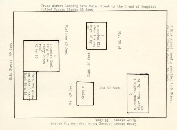
Colonial Lots 41 & 42 lie on the south side of Duke of Gloucester Street near the College of William and Mary. See: Tyler's adaptation of the College Map (1791?) opposite.
HISTORY:
Any history of a colonial lot in the James City county part of Williamsburg is difficult to write as most of the court records of James City county were destroyed by fire during the Civil War.
On the College Map (1791?) the two lots are designated #40 and #42. On the Bucktrout Map of Williamsburg (1803), the lots are shown as #41 and #42. Obviously, lots 40 and 41 are identical in location though different in numbering on the two maps. On both maps the name "Moir" appears.1
The first known occupant of this property appears to have been John Lockley, a bar-keeper, painter, plasterer, and ordinary keeper. Lockley may have lived at this site ca. 1773 though there is nothing definite in the sources to substantiate this statement. He was operating in Williamsburg from early 1773 to 1782. Within that space of time, there are various references to Lockley from the Virginia Gazette and some from more remote sources which will be given below:
[March 18, 1773]
Mr. PRATT, PORTRAIT PAINTER, 2 Lately from ENGLAND AND IRELAND
But last from NEW YORK,
HAS brought with him to Williamsburg a small but very neat Collection of PAINTINGS, which are now exhibiting at Mrs. VOBE'S near the Capitol, the Prices of which may be known by applying to Mr. Lockley, at the Bar;... 1
WILLIAMSBURG, November 24, 1774.
ALL Persons indebted to the Estate of John Pringle, deceased, late Bar Keeper to Mrs. Campbell of this City, are desired to make Payment, as soon as possible; and those who have any Demands against the said Estate are requested to bring in their Accounts, properly attested.
JOHN LOCKLEY, Administrator.2
Just below the above notice, Lockley stated that "IF Mr. John Cheek, who lodged and boarded with me about four Months ago, does not come, or send for a Portmanteau, containing some Wearing Apparel, which he left at my House for a Debt, by or before the 13th of December, they will be sold..."3
From the above two notices, we learn that Lockley kept bar at Mrs. Vobe's, that he had a house in the city in which he offered lodging and board.
By 1775 Lockley seems to have expanded his occupations by adding painting, plastering and paper hanging:
3WILLIAMSBURG, March 18, 1775
THE Subscriber begs Leave to acquaint the Public in general, and his Friends in particular, that he has engaged a Person, from London, who is a Proficient in PAINTING, PLAISTERING, AND PAPERHANGING, and hopes to give general Satisfaction to all those who please to employ him; which will oblige Their humble Servant,
JOHN LOCKLEY.N.B. Stolen out of my Yard, last Night, a white MUSCOVY DUCK, and a SUMMER DRAKE. Whoever brings them to me shall have a 5s. Reward.4
check C. Hubbard in Billiard Report for this lot
Lockley mentions his helper in the painting, plastering and paper hanging business and his yard but no hint as to the location of a shop or dwelling.
In June Lockley advertised thus:
WILLIAMSBURG, June 27, 1775.
FOUND, last Saturday Night, about 8 o'Clock, near the Playhouse, a Pair of new SADDLEBAGS, with a Brass Lock, the Contents unknown. The Owner is desired to apply for them, prove his Property, and pay Charges.
JOHN LOCKLEY. 1
In November, 1775 there is some hint as to Lockley's location in the city:
[November 4, 1775]2
TO be seen at Mr. John Lockley's, next Door to Mr. Gilbert's, Shoemaker, in WILLIAMSBURG, A CURIOUS PIECE OF WAXWORK, representing Venus relating to Adonis the Story of Hippomines and Atalanta. Price 1s.3
A study of Gilbert's activities and location in Williamsburg indicates that in January 1775 he was renting on Nicholson Street. If Gilbert lived on a "back street next door to Lockley," this would preclude Lockley living on Lots 41 & 42 Duke of Gloucester street in 1775.
However, it is definite that Lockley was living on Lots 41 & 42 by July, 1778:
[July 17, 1778]
TO be sold, at Mr. Lockley's near the college, in Williamsburg, a large quantity of dried COD FISH at 3-10s. per hundred, brown SUGAR 7s. per pound, and PLUMS 5s.4
The above notice looks as though Lockley may have gone into the 4 mercantile business. In 1779 Lockley still was taking roomers at his house:
[August 14, 1779]
FIVE HUNDRED DOLLARS REWARD
FOR apprehending the robber, and the recovery of a new hair trunk, taken out of my room at the house of Mr. Lockley, last night, containing the following articles, viz. Thirty six new shirts, 20 of them East India muslin, and 16 of holland, all ruffled, 20 muslin handkerchiefs, 12 white linen ditto, 6 cambrick ditto, 20 pair of white silk embroidered stockings, 13 pair of black ditto, 7 pair of Gray ditto, 24 cambrick and lawn stocks, 18 night caps of fine holland, 6 muslin ditto, 6 cravats of cambrick, and 12 pairs of socks; most of the above articles marked T. F. Whoever secures any part of the above articles, shall receive a reward proportionate.WILLIAMSBURG, August 10, 1779. DE FRANCY.
1
Lockley's house is noted again in January, 1780:
WILLIAMSBURG, Jan. 13, 1780.
LOST this morning, between Mrs. Vobe's tavern and the house of Mr. Lockley, a pair of saddle bags, containing a pound of pepper, a shirt, a stock, and sundry books and accounts wrote in French. Whoever delivers the said saddle bags, books, and accounts at Mr. Lockley's shall receive a reward of ONE HUNDRED DOLLARS.2
Lockley, evidently, had continued as a painter. One item of date, September 25, 1779 "Board of Trade Dr To John Lockley for 1 lb coperass 20lb ——£-.16.-".3
In July, 1780 Lockley was defendant in a suit in chancery in York county.4
The Frenchman's Map of Williamsburg (1782) indicates a large rectangular building on the lot at the northwest corner of the present Block 14. Three smaller outbuildings and possibly a fourth appear, also, on the map.5
When the Williamsburg Land Tax list begun in 1782, John Lockley is charged with having "2 lots with tax valuation of £8".6
5In 1785 the property changed owners. Wyatt Coleman is charged thus: "bout of John Lockley—2 lots—£ 8".1 Coleman was the son of Samuel Coleman of Gloucester county. In 1738 the father wrote to Francis Wiat [London] stating that he was married to the daughter of Francis Wiat in Virginia, that he had two sons and two daughters; the eldest, Wiat Coleman is a very promising boy.2
Personal Property Tax for Williamsburg for the year 1798 shows that Wyatt Coleman paid on a billiard table, 3 horses, 4 slaves and 4 wheels.3
Wyatt Coleman held the property until 1798 when it is charged to "Wiatt Coleman's Est."4
The map known as "The College Map (1791?) shows the name, "Moir" on Lots 40 & 42.5 The Bucktrout Map (1803) shows "Moir" on lots 41 & 42. (Both maps in Research Department.)
In 1801 James Moir, tailor, had become owner according to the tax records.6 Prior to October, 1773 a James Moir had advertised at Cobham, Surry county, for a journeyman tailor.7 In 1777 a James Moir of Williamsburg gave notice that he, a tailor "begs leave to inform the publick, that he has just opened shop above Mr. Robert Nicolson's,..."8 This was on the south side of 6 the Capitol. In 1796 Moir, apparently, held property on Francis Street occupied by Mrs. Saunders...1 Moir married Elizabeth Diddip, daughter of another Williamsburg tailor.2
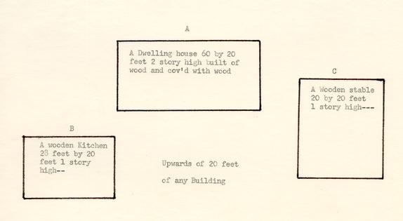
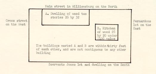
By 1802 it is definite that Moir was living on Lots 41 and 42. An insurance policy taken out by him give his location thus: "My three buildings on the Main Street at the sd place [Williamsburg] now occupied by myself situated between the Lot of Coll Travis and that of Wm Durfy in the county of James City...Dwelling house 60 by 20 feet 2 story of wood, wooden kitchen 28 by 20 feet 1 story and wooden stable 20 by 20 feet..."3
In the estate papers of Benjamin Taliaferro of James City county there are long and detailed accounts of Moir's tailoring from 1797-1801.4 Moir made not only suits for Mr. Taliaferro and his sons but for his overseer, servant's clothes, a horseman's coat of red velvet &c. For Sir Peyton Skipwith he made repairs to his clothes, altered breeches, lined waistcoats and put in new pockets.5
In 1806 Moir again insured his property: "...three Buildings on the main street of sd Williamsburg now occupied by myself situated between a cross street leading from main street to College Landing and William Durfeys Lott in the county of James City...Dwelling House 24 by 36, Kitchen 26 by 20 and Stable 20 by 20."6
In the two policies quoted from above—#591 (1802) and #620 (1806)—there 7 are changes within four years which should be pointed out: in 1802, the dwelling house is 60' by 20' with 2 stories; in 1806, the dwelling house is 24' by 36' with 1 story Dutch roof, a west wing 38' by 18' is attached. In both policies the kitchen and stable have about the same dimensions. The valuation for 1802 is $750; the valuation for 1806 is $1600. If these policies refer to the same house, considerable changes had taken place as to size, shape and valuation. Whether a fire destroyed the 1802 building and the 1806 building was completely new, or whether radical changes were made to the first building in 1806, is not known. Excavations may be able to clear this mystery.1
Williamsburg Land Tax lists James Moir as owning 2 lots valued for tax purposes at $40 (1801-1805); $60 (1806); $70 (1807) and $80 (1808-1810).2
In 1811 the tax records indicate that Thomas Turner had come into "2 lots valued at $100 via Moire."3
Personal Property Tax for Williamsburg show that in 1809 Thomas Turner paid license as a retail merchant. He continued to pay each year through 1821.4
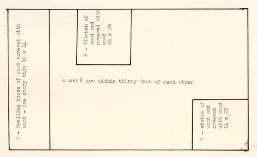
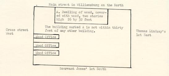
In 1815 Turner insured the property acquired from Moir with the Mutual Assurance Society thus: "...buildings...occupied by myself situated between Durfeys lot on the East and Travis' lot on the south...dwelling house 36' by 24', kitchen 26' by 20' and stable 24' by 20'...valuation of dwelling house $1500..."5 (For Durfey and Travis lots, see: house histories of Lot 8 350 and Lots I & K, Research Department). No storehouse noted.
In 1822 Turner bought Lot 350 east. (See: House History 350).
By 1823 Turner had died. His administrator, William Donnelly, insured the property stating that Jesse Cole was east and Samuel Travis south; dwelling valued at $1667.1
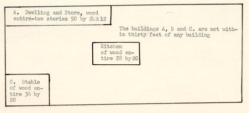
Again, in 1830 Donnelly insured the property. This time it was occupied by Mrs. Gamble with Samuel Travis on the south and Bowery on the east. Dwelling and store valued at $1250 with dimensions given as "50 by 24 & 12." Stable is 36 by 20, and kitchen 28 by 20.2 Whether Mrs. Gamble used the store or whether it was rented to another merchant, is not known from available sources.
It looks as though William H. Welsh, retail merchant, rented the store from 1834 through 1838. He is listed as a retail merchant paying license tax of $20 during these years. See: statement from Southall Papers to follow.
In January, 1836 Mrs. Turner had certain repairs made to the property by Richard T. Booker, local carpenter. There were such changes as new weather-boarding, moving door, casing door with architraves, making 6-panel door and hanging, changing window &c.3 J. T. Bowery was occupying a room in the house when the work was done.4
In 1838 Mrs. Elizabeth Turner, widow of Thomas Turner, was dead. Thomas O. Cogbill, a lawyer, was negotiating for the sale of the property 9 to Scervant Jones, minister, if satisfactory arrangements could be made with the present renter, William H. Welch:
1838 Elizabeth Turner Estate Mr. S. Jones has accounted with me for one half of Wm H. Welch's Rent already accrued for the rent of the House and lot in Williams-burg belonging to Elizabeth Turner, and I have also recd of the said S. Jones his bond for the sum of Five hundred dollars to carry interest from this day, being the amount of the purchase money and I promise to have a deed executed for the said house and lot to said Scervant Jones, warranting the title thereto, and all Taxes and Insurance to be paid up to this day by the said E. Turner...August 15th 1838.
[Endorsed on back] Tho: O: Cogbill.In consideration that the sum of Fifteen Dollars 62 ½ cents is given up to my in my Rent of the House & Lot of Elizabeth Turner, already accrued, and a full release for the balance of the year, I do hereby agree & bind myself to give immediate possession of the said Tenement to S. Jones should he become the purchaser of the same. Witness my hand & Seal this 15 day of Augt 1838.
Wm H. Welsh (Seal)"1
Prior to this arrangement above, Richard Coke, guardian of Mary Jane and Elizabeth Turner, children of the deceased Thomas Turner, paid R. T. Booker, local carpenter, for repairs such as 1500 pales, 210 rails, 2 gates, 431 pine rails and 25 posts. A division was made to the lot by fences: "Division between Welsh," "Division between Bowery" and "Division between Bowery and Mrs. Gamble."2
Scervant Jones secured the property by 1839 as he had insured it thus: "...my buildings on my own land and situated between the lot on which I reside on the south, a cross street on the West and the main Street in Williamsburg on the north in the county of James City...Dwelling 26' by 32' two stories and kitchen 28' by 20'...total valuation $1750."3
Williamsburg Land Tax charges Jones in 1840 with "1 lot with 10 building $1000 Via Elizabeth Turner daughter of Thos Turner decd."1
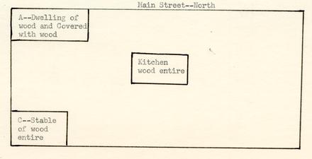
Jones held the property until his death in 1854. During his ownership he insured the property thus: 1840—"occupied by self...bounded on the east by Thomas Lindsay, a lot of his on the south, a cross street on the west and the main street north. Dwelling two stories high 26' by 32' valued at $2000; 3 wood offices on street to west."2 1846: "...dwelling two stories all wood, kitchen, wood building near kitchen, three wood dwellings at street to west."3 1853: "...building on the Main and a Cross street now occupied by myself situated between the lot of the Eastern Lunatic Asylum on the South and the East by the lot of—Dwelling $2000 two stories of wood."4
While Jones was living at this site, he took William and Mary College students to live with him. He began taking students in the session 1838-39 when he had four. Session of 1839-40 there were 16 students; session 1840-41, there were 13 students, session 1845-46 12 students; 1846-47 there were 6 students, 1847-48 students numbered 11.5 1847-49 session seems to be the last date at which Jones boarded or roomed students.
It seems reasonable to believe that the three wood offices shown on the insurance policy of 1840, were used as rooming quarters for the students. They were not shown in 1839 when Turner's heirs were owners. Insurance valuation changed from $1750 in 1839, to $2000 in 1840. Jones in all probability erected these buildings immediately following his acquisition of 11 the property.
At the time of the death of Jones, the lot was valued at $1800 with $800 for buildings.1 Jones' family held the property until 1859 when it became into ownership of Charles C. P. Waller. At this date the tax valuation was $3000 for lot and buildings, $2600 buildings.2
Though there is a reference to the will of Jones and his executor, Robert Saunders, research has not been able to locate such will or any settlement of Jones' estate.
The Virginia Gazette published in Williamsburg by Peyton & Neel, November 17, 1854 gave notice of the executor's sale thus: "...I shall sell at Public Auction, at the late residence of the Rev. SCERVANT JONES, dec'd, in Williamsburg, the personal property of the deceased (except Slaves) left by him at the said residence..."3 Because records were largely destroyed during the Civil War, no account of this sale has been found.
In 1860 Waller insured the newly acquired property thus: "...my building on the South side of Main Street now occupied by Myself situated between the property of—on the East, the lot of the Eastern Asylum on the South and a cross Street on the West in the said City of Williamsburg and in the county of James City...Dwelling $2000 of wood 2 stories. [no other buildings insured]."4
Charles C. P. Waller was the son of Benjamin Waller, son of Benjamin Carter Waller who lived behind the Capitol on Waller Street. Charles C. P. Waller attended William and Mary College. He was steward at Asylum 1852- 12 1858 and clerk and storekeeper 1861-62 when he was removed for political causes.1
In 1861 Waller's property is valued in the Land books as $3000 for lot with buildings; and $2600 buildings.2
Sometime between 1861 and 1865 the building was destroyed by fire. In the Williamsburg Land Book, for 1865, Charles C. P. Waller is charged in fee simple with a lot of land including buildings assessed at $1200. A note states: "Residence entirely destroyed." Other buildings were valued at $800.3
Mr. John S. Charles, an old citizen of Williamsburg, gave his recollections of the city as he remembered it during the Civil War period. He explains the fate of this old house thus:
"On the lot, extending from within a few feet of the Bunting lot to the corner of Duke of Gloucester and Henry streets, thence south-ward along Henry street to the property of the Eastern Lunatic Asylum (then the legal title of the Eastern State Hospital) stood a very large and attractive frame dutch-roof house, with platform along the side and end with substantial railing, with its front on side facing Duke of Gloucester street. The western end of this big house was distant about forty feet from Henry street. To the south and west of this house was a beautiful grass lawn. On the rear of this lawn was a large kitchen and servants' quarters. At the eastern part of this lot was a vegetable garden, right on the street and enclosed with a five foot fence made of cypress palings, which were much used here at that time. The front yard was enclosed by an attractive picket fence with cap. Along Henry street there were three frame buildings. The one nearest the corner was a single story structure; the other being two stories.
These houses were spoken of as "offices" and fronted on Henry street and also with back doors on the lawn and were used as lodging rooms for the students.
The widely known Rev. Scervant Jones once owned and lived in this house, and many are the stories told about the unique character; a man of exalted piety and recognized ability. This property was owned and occupied when the war began by Mr. Charles P. Waller, 13 who was then an officer of the asylum, and also conducted a students boarding house, at which many of the students of old William and Mary were royally entertained. This grand old home, being vacant during the War, like nearly all unoccupied houses, it fell a prey to the vandals and was not rebuilt.
After the War, the lot was divided up and sold. One of the offices just described was, not long since, on the back part of the lot in which it formerly stood, having been removed to make room for the more modern building which occupies the site of this old structure which once sheltered so many of Virginia's noble sons. The single story office stood next to the corner and has been long since removed; while the other two-story office is still on its original site, near the hospital line, fronting on Henry street, and now owned and occupied by negroes."1
Mrs. Martha Vandergrift recalling Williamsburg in 1844 said this of the Rev. Scervant Jones: "He was a fine looking old man. He put up a monument to his wife one day, and next day went off and married some one else. He was a Baptist preacher. I don't know where he preached. He lived in the country. He didn't live in town."2
As Mr. Charles recalled, Waller split up the lot into several parts in 1866. One part was granted to George Washington, freedman, thus:
14[April 16, 1866]
...Waller grants a lot with houses in Williamsburg bounded as follows Viz: On the South by the lot sold by the said Chas C. P. Waller & wife to Frederick Smith freedman of Color, on the East by the lot of J. Bunting3 on the North by a straight line drawn from the Middle point between the house on the lot hereby conveyed and the house next adjacent to it on the street leading from the Main Street to the College landing and on the West by the Street just mentioned as leading to the college landing the said lot of land being a part of the lot heretofore sold to the said Chas C. P. Waller by R: Saunders Executor of the Rev. Scervant Jones deceased under the will of said Jones...4
The same day, April 16, 1866, Waller granted the northern portion of the lot to Mary A. Bowry and children by trustee, Richard B. Bassett:
[April 16, 1866]
...a certain lot of land in the City of Williamsburg, bounded as follows to wit: North by the Main Street, South by a lot of land conveyed by said C. C. P. Waller to George Washington by deed bearing even date herewith, East by the lot now owned by J. Bunting, West by the cross street leading from the main Street to the College Landing the said lot of land being a part of the lot heretofore sold to the said Charles C. P. Waller by Robert Saunders Executor of the Rev. Scervant Jones decd under the will of said Jones...In trust, nevertheless, that the said Richard B. Bassett shall hold the said lot of land for the entire, sole, separate and exclusive use of Mary A. Bowry, the wife of Richard A. Bowry, and her children, and shall at all times permit the said Mary A. Bowry to occupy and control as to her seems fit...1
By deed of June 4, 1866 George Washington and wife conveyed the property acquired by them to Virginia A. Goodman through trustee.2
On March 22, 1867 Bassett as trustee conveyed to Tyler Davis, trustee for Jane E. Davis:
[March 22, 1867]
...the land described in the deed of April 16th 1866 above quoted.
In 1889 Tyler Davis as trustee for Jane E. Davis, conveyed to John A. W. Jones a portion of the lot as follows:
[June 3, 1889]
...A portion of the lot of land upon which the said Jane E. Davis now resides, and bounded as follows: North by Duke of Gloucester Street, south by the land of Mrs. Goodman,3 east by the land of 15 R. F. Cole's heirs, and west by the remaining portion of the lot of Mrs. Jane E. Davis; the lot hereby conveyed fronts seventy (70) ft. on the Duke of Gloucester Street, and is the same width on the southern boundary...1
The southern part of the lot was sold in 1878 and again in 1892:
...Virginia A. Goodman by trustee gave deed of trust for the property acquired by her from George Washington, freedman, to John H. Barlow Jr, trustee to secure Bushrod W. Bowery in the sum of $188.76. Finally, on February 13, 1892 the heirs of Virginia A. Goodman, decd, conveyed to John A. W. Jones the aforesaid property described as follows:
All that certain lot of land with the buildings thereon, formerly the residence of the said Virginia A. Goodman, deceased, and bounded as follows: North by a straight line drawn from the middle point between the house hereby conveyed and the house adjacent to it, south by the lot of Frederick Smith, east by the lot known as the Bunting lot, west by Henry street...2
Further study of these deeds can be seen in Abstracts to Title (1173, Block 14, No. 24 Goodall; and 1238, No. 22 Friedman) Accounting Department, Colonial Williamsburg or at James City and the City of Williamsburg courthouse.
Footnotes
Illustration #1
FROM FRENCHMAN'S MAP 1782?
Illustration #2
| 1782 | John Lockley | 2 | lots | valuation £ 8 |
| 1784 | 2 | lots | £ 8 | |
| 1785 | Wyatt Coleman bout of John Lockley | 2 | lots | valuation £ 8 |
| 1787 | Wyatt Coleman | 2 | lots | £18 |
| 1789 | 2 | lots | £12 | |
| 1790-1796 | 2 | lots | £18 | |
| 1798 | Wyatt Coleman's Estate | 2 | lots | valuation $40 |
| 1799 | Wyatt Coleman's Est | 2 | lots | $ 40 |
| 1801 | James Moir | 2 | lots | $ 40 |
| 1804 | James Moire | 2 | lots | $ 40 |
| 1806 | James Moire | 2 | lots | $ 60 |
| 1807 | James Moire | 2 | lots | $ 70 |
| 1809 | James Moire | 2 | lots | $ 80 |
| 1810 | James Moire | 2 | lots | $ 80 |
| 1811 | Thomas Turner | 2 | lots | $ 100 via Moire |
| 1812-1818 | Thomas Turner | 2 | lots | $ 100 via Moire |
| 1819 | Thomas Turner | 3 | lots | $ 210 1 via George Watts house and lot on the south side of the main street, and formerly charged to the said Watts [Watts had bt. 1 lot $50 via Shields in 1812. Shields bt ¼ lot $20 in 1809 via Collin Cock. In 1802 Collin Cock bt ¼ lot via Coleman $20. Do not know where this lot is located] |
| 1820 | Thomas Turner | 1 | lot | $ 450 Lot & bldgs; $ 400 bldgs |
| 1 | $1950 $1800 | |||
| 1 | $ 220 $ 200 | |||
| 1823 | Thomas Turner | 1 | lot | $ 450 Lot & bldgs; $ 400 bldgs |
| 1 | lot | $1950 $1800 | ||
| 1 | lot | $ 220 $ 200 | ||
| 1 | lot | $ 400 $ 300 | ||
| 1824-1838 | Thomas Turner | 1 | lot | $ 450 Lot & bldgs; $ 400 bldgs |
| 1840 | Scervant Jones | 1 | lot | $1000 $ 800 Via Elizabeth Turner daughter of Thos Turner decd |
| 1843 | Scervant Jones York County | 1 | lot | $1500 $1200 This property has been conveyed to the Eastern Asylum but it does not appear on tax transfers, the Comm. presumes that the deed was not recorded in time-Both lots in like predicament. |
| 1 | $ 300 $ 200 | |||
| 1845 | Scervant Jones Wmsburg | 1 | lot | $1000 $ 800 |
| 1851 | Scervant Jones | 1 | lot | $1800 $1500 |
| 1854 | Scervant Jones Est | 1 | lot | $1800 $1500 |
| XLots I & K & Lot M. | ||||
| 2 | ||||
| 1858 | Scervant Jones Est | 1 | lot | $3000 $2600 |
| 1859 | Chas. C. P. Waller | 1 | lot | $3000 $2600 |
| 1861 | Charles C. P. Waller | 1 | lot | $3000 $2600 |
| 1786 | Wyatt Coleman | 7 slaves | 3 horses | 4 wheels | |||||
| 1788 | 3 slaves | 2 horses | 4 wheels | ||||||
| 1789 | 1 slave | 2 horses | 4 wheels | ||||||
| 1790 | 2 slaves | 1 horse | 4 wheels (phaeton) | ||||||
| 1791 | 2 slaves | 5 horses | 2 wheels (chair) | ||||||
| 1792 | 2 slaves | 2 horses | 4 wheels (phaeton) | ||||||
| 1793 | 4 slaves | 3 horses | 4 wheels (chariot) | ||||||
| 1794 | 4 slaves | 3 horses | 4 wheels | 1 billiard table | |||||
| 1796 | 2 slaves | 1 horse | |||||||
| 1800 | James Moir | 5 slaves | 1 horse | ||||||
| 1801 | 6 slaves | 1 horse | |||||||
| 1802 | 6 slaves | 1 horse | |||||||
| 1803 | 7 slaves | 1 horse | |||||||
| 1811 | [No Moir listed] | ||||||||
| 1809 | Thomas Turner retail license $15 | ||||||||
| 1815 | Thomas Turner | 3 blacks | 2 horses 3 cattle 1 wheel 1 side board $100 1 table 3 calico curtains, 3 pictures above 12 in, 2 do gilt frames under 12 in., 1 looking glass of 2 & under 3 feet, 1 harpisicord under $300 1 chest drawers | ||||||
| 1815 | Thomas Turner retail license $20 | ||||||||
| 1816-1821 | [same] | ||||||||
| 1818 | Thomas Turner | 4 blacks | 2 horses | ||||||
| 1820-1823 | Thomas Turner retail license #20 | ||||||||
| 1823 | [no Thomas Turner listed] | ||||||||
| 1833 | Scervant Jones | 3 slaves | |||||||
| 1834 | William H. Welsh retail license $20 | ||||||||
| 1834-1838 | William H. Welsh retail license $20 | ||||||||
| 1833-1854 | Scervant Jones- | slaves | 3 horses | 1 wheel | |||||
| 1854 | Charles C. P. Waller- | 3 slaves | 4 cattle | ||||||
| 1860 | Charles C. P. Waller | 4 slaves |
Illustration #3
Insurance Policy #591 Declaration for Assurance with the Mutual Assurance Society.
February 18, 1802
I THE underwritten James Moir residing at Williamsburg in the county of James City do hereby declare for Assurance...My three buildings on the Main Street at the sd place now occupied by myself situated between the Lot of Coll Travis and that of Wm Durfy in the county of James City...
| The Dwellings | marked A | at 750 Dollars |
| The Kitchen | do B | at 150 do |
| The Stable | do C | at 100 do |
| 1000 Dollars in all. |
Insurance Policy #620, revaluation of buildings with the Mutual Assurance Society per Declaration #591
February 11, 1806
I the underwritten James Moir residing at Williamsburg in the county of James City do hereby declare for Assurance ... My three Buildings on the Main street of Williamsburg now occupied by myself situated between a cross street leading from Main street to College Landing and William Durfeys Lott in the county of James City...
| The Dwellings | House marked A | at 1600 Dollars |
| The Kitchen | B | at 190 Dollars |
| The Stable | C | at 100 Dollars |
Insurance Policy #1528 Revaluation of Buildings formerly declared for assurance by James Moir—per declaration No. 620
July 5, 1815
I the underwritten Thomas Turner residing at Williamsburg in the county of James City do hereby declare for assurance in the Mutual Assurance Society against fire on buildings of the state of Virginia my buildings on the Main street in Williamsburg now occupied by myself situated between Durfeys lot on the East and Travis' lot on the south in the County of James City...
| The Dwelling house | A | at $1500 |
| The Kitchen | B | at 150 |
| The Stable | C at | 150 |
| $1800 |
(Copy in photostat in Department of Research)
Mutual Assurance Society #5025 revaluation of buildings formerly declared for assurance by THOMAS TURNER per declaration #1528
April 8, 1823
I the underwritten William Donnelly admor of Thomas Turner residing at Williamsburg in the county of York do hereby declare for Assurance in the MUTUAL ASSURANCE SOCIETY against fire...the buildings on Thomas Turners lot now occupied by no person situated between the lots of Samuel Travis's South, Jesse Cole East, and streets otherwise in the county of James City...
| The Dwelling | A at | $1667 |
| The Kitchen | B at | 134 |
| The Stable | C at | 150 |
| $1951 |
Mutual Assurance Society #7605 revaluation of buildings declared for Assurance by Wm Donnelly as admor of Thomas Turner as per declaration #5025
May 30, 1830
...That the said Buildings are at present owned by the heirs of Thomas Turner residing at Williamsburg and are occupied by Mrs. Gamble That they are situated on the main street in Williamsburg on the North, a cross street on the West, the lot of Samuel Travis on the south, and a lot occupied by Bowery on the East in the county of James City...
| The Dwelling and Store | A at | $1250 |
| The Kitchen | B at | 100 |
| The Stable | C at | 50 |
| $1400 |
Mutual Assurance Society #11007 revaluation of buildings formerly declared for Assurance by Thomas Turner's heirs per declaration #7605 May 25, 1839
I the underwritten Scervant Jones residing at Williamsburg in the county of James City do hereby declare for Assurance in the MUTUAL ASSURANCE SOCIETY against fire...my buildings on my buildings on my own land now occupied by and situated between the lot on which I reside on the south, a cross street on the West and the main street in Williamsburg on the north in the county of James City...
| The Dwelling | A at | $1750 |
| The Kitchen | B at | |
| $1750 |
Mutual Assurance Society Policy #11193 revaluation of buildings formerly declared for assurance by SCERVANT JONES per Declaration #11007 December 28, 1840
I the underwritten Scervant Jones residing at Williamsburg in the county of James City do hereby declare for Assurance in the MUTUAL ASSURANCE SOCIETY against Fire...
My building on my own lot now occupied by myself and situated between the lot of Thomas Lindsay on the East, another lot of mine on the South, a cross street on the West and the main street in Williamsburg on the North in the county of James City...
| The Dwelling | A at | $2000 |
| $2000 |
Mutual Assurance Society Policy #14,397 revaluation of building formerly declared for assurance by SCERVANT JONES October 3, 1846
I the underwritten Scervant Jones residing at Williamsburg in the county of James City do hereby declare for Assurance in the MUTUAL ASSURANCE SOCIETY against Fire...my Building on the Main street now occupied by myself situated between the Main street on the North a Cross street on the West, and a lot of the Eastern Asylum on the South in the county of James City...
| The Dwelling | A at | $2000 |
| $2000 |

Mutual Assurance Policy #17642 revaluation of building formerly declared for assurance by SCERVANT JONES per declaration #14397
November 14, 1853
I the underwritten Scervant Jones residing at Williamsburg in the county of James City do hereby declare for Assurance in the MUTUAL ASSURANCE SOCIETY against Fire...my Building on the Main and a Cross street now occupied by myself situated between the lot of the Eastern Lunatic Asylum on the South and on the East by the lot of in the county of James City...
| The Dwelling | A at | $2000 |
| $2000 |

Mutual Assurance Society Policy #21349 revaluation of building formerly declared for assurance by SCERVANT JONES per Declaration #17642
December 31, 1860
I the underwritten CHARLES C. P. WALLER residing at Williamsburg in the county of James City do hereby declare for Assurance in the MUTUAL ASSURANCE SOCIETY against Fire...my Building on the South side of Main Street now occupied by myself situated between the property of on the East, the lot of the Eastern Asylum on the South and a cross Street on the West in the said city of Williamsburg and in the county of James City...
| The Dwelling | A at | $2000 |
| $2000 |
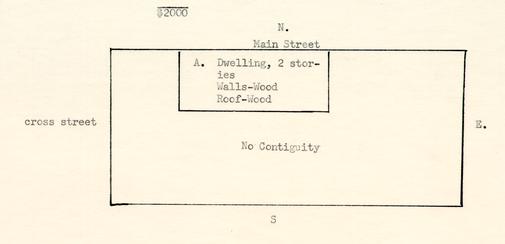
Illustration #4
Southall Papers, Folder 194 Legal Cases and Estates. Williamsburg. Library, College or William and Mary.Booker (Richard T.) constable of Williamsburg. Statements, receipts and other papers. 1818-1843. 307 Pieces.
| "January 6th 1836 Mrs Turner Dr To Richard T Booker | |
| To 1sqr & 43 feet of weather boarding at $1 pr Sqr | $1.43 |
| To moving Door $2 to casing door with archatrives &...[illegible]... | 400 |
| To making 6 panel door fiting & hanging & puting on each | 350 |
| To taking out & puting window in another place | 1.50 |
| To puting in 2 studes at 13 Cts each | 26 |
| ... | $10:69 |
I will pay the above account, amounting to Ten Dollars & sixty nine Cents, on demand-witness my hand & seal this 30th August 1836.
SS
[On back in different handwriting]
Mrs. Turner-
I will pay the amount of the within account out of the rent of the room at this time ocupyed by me by the request of Mrs Turner...
[June 4, 1838]
J. T. Bowery seal"
Southall Papers, College of William and Mary Folder 328Accounts. Williamsburg 1821-1850 103 pieces.
"1837. Thomas Turners Est To the Collector of Williamsburg To tax on lot 60¢Southall Papers, Legal Cases and Estates. Williamsburg. Folder 194, College of William and Mary.
Corporation levy on Value 100....1.60 [Endorsed on back]
Recd pay Geo W MCandlish colr"
Booker (Richard T.) constable of Williamsburg. Statements, receipts and other papers. (1818-1843.) 307 pieces.
| Mr. Richard Coke guardian Miss Mary Jain [sic] & Elizabeth Turner R T Booker Dr [date 1838] | |
| "To 1500 pails at 84 Cts per 100 | $12.60 |
| To 210 hewed Chestnut rails at 6¼ ct each | 13.12½ |
| To... [illegible 89?] posts at 12½ Cts each | 10.12½ |
| To puting up 76 panels of pails at 25 per... [illegible] | 19.00 |
| to 2 gaits compleat | 3.00 |
| to hinges 75 to 50 Cts of rails | 5.75 |
| to repairing 5 panels pails | 64 |
| $64:22½ |
| [On back; or rather on the other page] | |
| William H. Lee | |
| to 431 pine rails at 8 Cts [illegible] | $3.78 |
| to 72 railes at 6 [illegible] | 4.38 |
| to 25 post at 12½ | 3 00 |
| to putting up 24 pannells at 25 | 6 |
| $17:76 |
| Coke | |
| 408 | pailes front |
| 45 | railes |
| 20 | posts |
| 21 | panels new |
| Division | between Welsh |
| 140 | pailes |
| 21 | railes |
| 7 | pannells |
| Division | bettene Bowery |
| to 433 | pailes |
| to 72 | railes |
| to 24 | pannells |
| to 24 | post |
| Division | beteene... [illegible Bowery?] and Mrs Gamble |
| to 480 | pailes |
| to 72 | railes |
| to 24 | pannills |
| to 25 | post |
| to Making | Fitting hanging |
| 2 gates |
Folder 182 Legal Cases and Estates. James City County.
1838 Turner (Elizabeth) estate. 1 piece.
"Mr S. Jones has accounted with me for one half of Wm H. Welch's Rent already accrued for the rent of the House and lot in Williamsburg belonging to Elizabeth Turner, and I have also recd of the said S. Jones his bond for the sum of Five hundred dollars to carry interest from this day, being the amount of the purchase money and I promise to have a deed executed for the said house and lot to said Scervant Jones, warranting the title thereto, and all Taxes and Insurance to be paid up to this day by the said E. Turner. —August 15th 1838.
Th: O. Cogbill."[Endorsed]
[on the back is written.]
"In consideration that the Sum of Fifteen Dollars 62½ cents is given up to me in my Rent of the House & Lot of Elizabeth Turner, already accured, and a full release for the balance of the year, I do hereby agree & bind myself to give immediate possession of the said Tenement to S Jones should he become the purchaser of the same. Witness my hand & Seal this 15 day of Augt 1838.
Wm H. Welsh Seal"
James City County and the City of Williamsburg
Deeds, Book I, page 20
1866 April 16th; recorded April 17th, 1866Waller, Charles C. P. & wife, grantor
to
Bowry, Mary A. & children by trustee, Richard B. Bassett, grantee Consideration $500."...a certain lot of land in the City of Williamsburg, bounded as follows to wit: North by the Main Street, South by a lot of land conveyed by said C. C. P. Waller to George Washington by deed bearing even date herewith, East by the lot now owned by J. Bunting, West by the cross street leading from the main Street to the College Landing the said lot of land being a part of the lot heretofore sold to the said Charles C. P. Waller by Robert Saunders Executor of the Rev. Scervant Jones decd under the will of said Jones..."
"In trust, nevertheless, that the said Richard B. Bassett shall hold the said lot of land for the entire, sole, separate and exclusive use of Mary A. Bowry, the wife of Richard A. Bowry, and her children, and shall at all times permit the said Mary A. Bowry to occupy and control as to her shall seem fit."
James City County and the City of Williamsburg Court Records
Deeds, Book I, page 22
1866, April 16th recorded.Deed between C. C. P. Waller & wife and George Washington freedman:
"Waller grants a lot with houses in Williamsburg bounded as follows Viz: On the South by the lot sold by the said Chas C. P. Waller & wife to Frederick Smith freedman of Color, on the East by the lot of J. Bunting on the north by a straight line drawn from the Middle point between the house on the lot hereby conveyed and the house next adjacent to it on the street leading from the Main Street to the College landing and on the West by the Street just mentioned as leading to the college landing the said lot of land being a part of the lot heretofore sold to the said Chas C. P. Waller by R: Saunders Executor of the Rev. Scervant Jones deceased under the will of said Jones..."
By deed June 4th 1866, recorded June 16th 1866 in (Deed Book #1, pp. 35-6) George Washington and wife conveyed the property acquired by them to Virginia A. Goodman through trustee. [This part of the lot lay to the south and bordered on Henry Street (called "the main street to the College Landing].
James City County and the City of Williamsburg
Deeds, Book I, pp. 72-3.
1867, February 18, recorded March 22, 1867:Richard B. Bassett as trustee for Mary A. Bowry, wife of Richard R. A. Bowry, conveyed with general warranty to Tyler Davis, trustee for Jane E. Davis, the land described in the deed of April 16th 1866 above quoted. Tyler Davis, in June 3, 1889 as trustee for Jane E. Davis conveyed to John A. W. Jones a portion of the lot as follows:
"A portion of the lot of land upon which the said Jane E. Davis now resides, and bounded as follows: North by Duke of Gloucester Street, south by the land of Mrs. Goodman, east by the land of R. F. Cole's heirs, and west by the remaining portion of the lot of Mrs. Jane E. Davis; the lot hereby conveyed fronts seventy (70) ft. on the Duke of Gloucester Street, and is the same width on the southern boundary." (Deed Book #2, pp. 303-4).
The southern part of the lots were sold in 1878; and again in 1892:
Virginia A. Goodman by trustee gave a deed of trust for the property acquired by her from George Washington, freeman, to John H. Barlow jr. trustee to secure Bushrod W. Bowery in the sum of $188.76. Finally, on February 13th, 1892 the heirs of Virginia A. Goodman, decd, conveyed to John A. W. Jones the aforesaid property described as follows:
"All that certain lot of land with the buildings thereon, formerly the residence of the said Virginia A. Goodman, deceased, and bounded as follows: North by a straight line drawn from the middle point between the house hereby conveyed and the house adjacent to it, south by the lot of Frederick Smith, east by the lot known as the Bunting lot, west by Henry street." (Deed Book #2, page 424)